Building a living “Digital Twin” of grassroots government
OmniTwin unifies Big Data, Artificial Intelligence, 2D/3D digital maps and Digital Twin technology on a single shared core platform — replacing dozens of disconnected systems with one data repository, one sign-on and one real-time operating picture of the whole locality.
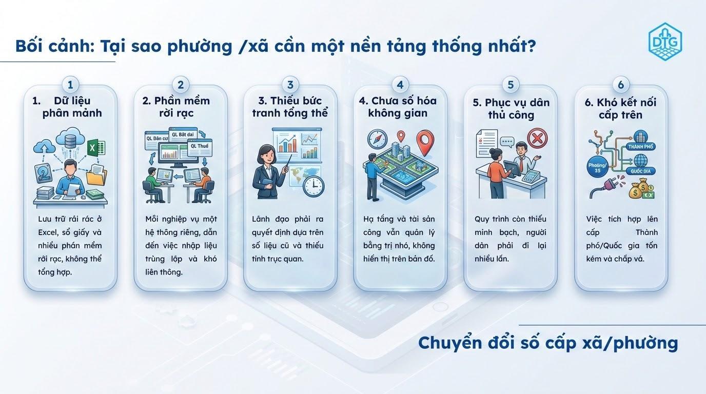
Six bottlenecks recur in almost every grassroots administration — the reason data goes unused, decisions come late and residents have to travel back and forth.
Records scattered across Excel files, paper ledgers and disconnected software, impossible to consolidate.
Every function runs its own system, forcing duplicate data entry with no interoperability.
Leaders must decide on stale figures with no visual context.
Infrastructure and public assets are still tracked from memory rather than shown on a map.
Processes lack transparency and residents must make repeated trips in person.
Integrating with city and national systems is costly and patched together.
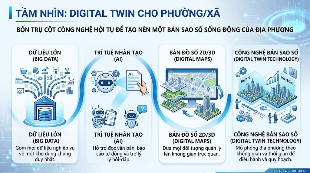
Four technology pillars converge to create a living digital replica of the locality.
Consolidates every operational dataset into one shared repository — standardise once, use everywhere.
Reads documents, generates reports automatically and answers questions for officials and residents alike.
Places every managed object in visual space — see location, relationships and current condition at a glance.
Simulates the locality across space and time for day-to-day operations and long-term planning.
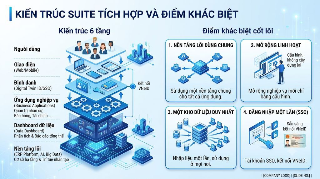
One core platform carries every business function — extended by configuration rather than rebuilt from scratch.
Leaders, specialist officials and residents on one and the same system.
Consistent experience from desktop and mobile alike.
One account across the whole system, ready to connect to VNeID.
HR administration, sales, finance and sector-specific operations.
Analytics and consolidated reporting in real time.
Infrastructure and artificial intelligence — the shared foundation beneath every application.
A single common platform serves every application — no more one isolated system per function.
New business functions are added through configuration, with no software rebuild.
Enter data once, use it anywhere — no duplication, no manual reconciliation.
One unified SSO account, ready for VNeID identity integration.
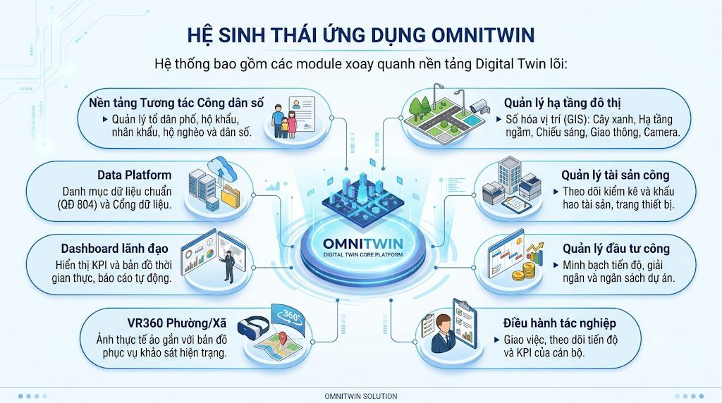
Each module solves a specific operational problem, yet all of them share one data repository and one identity layer.
Manages residential groups, household registers, population records and poor-household status in one unified data profile.
A standard data catalogue per Decision 804 plus a data portal for sharing and interoperability.
Real-time KPIs and maps with automated reporting — the whole locality on a single screen.
Map-linked virtual reality imagery for surveying conditions without repeated field trips.
Visit VR360 ↗GIS-based digitisation of green spaces, underground utilities, street lighting, traffic and cameras.
Tracks inventory and depreciation of assets and equipment — what exists, where it is, what condition it is in.
Transparent project progress, disbursement and budget at every stage.
Assigns tasks and tracks progress and KPIs per official — managing work instead of managing paperwork.
Each product solves a complete operational problem and can be deployed on its own — while sharing the OmniTwin platform’s data repository, identity layer and maps. Detail pages and brochures are currently published in Vietnamese.
Centralised management of residents, households, population records and social welfare; 2D/3D GIS resident mapping, residential-group management and a field-report channel for citizens.
A grassroots Data Platform: consolidates multi-sector data into one shared repository, standardises the catalogue per Decision 804, and adds dashboards, GIS maps and automated reporting.
Fully digitised administrative work: incoming/outgoing documents and case files, task assignment and progress monitoring, an AI assistant that reads dispatches, and digital-certificate expiry alerts.
The full life cycle of a public investment project across the 10 statutory steps: projects, bid packages, capital plans, disbursement, versioned documents and overdue alerts.
One screen covering all four blocks — Party Committee, People’s Council, People’s Committee and Fatherland Front: real-time KPIs, 2D/3D maps, smart alerts and an AI assistant.
End-to-end meeting automation: speech-to-text, speaker recognition by seating position, and a standards-compliant set of minutes generated in 30 to 60 seconds.
Full presentation of the Digital Twin platform for wards and communes · PDF · 1.7 MB · Vietnamese
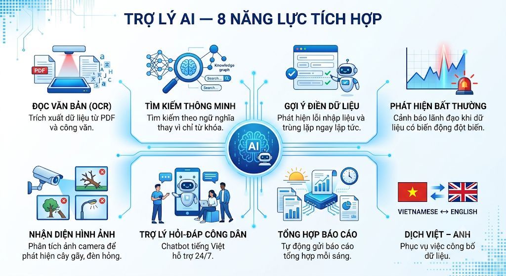
AI is not a bolt-on feature — it lives inside the core platform, serving officials and residents alike.
Extracts data from PDFs and official dispatches instead of retyping it by hand.
Searches by meaning rather than exact keyword matching.
Flags input errors and duplicates the moment they occur.
Alerts leadership whenever the data shows an unusual swing.
Analyses camera imagery to spot fallen trees, broken lights and other infrastructure faults.
A Vietnamese-language chatbot supporting residents around the clock.
Sends a consolidated report every morning — no official has to stitch figures together.
Supports bilingual publication of open data.
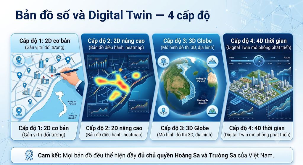
A locality can start at the level that matches its existing data and budget, then move up without ever starting over.
Puts every managed object on a base map — know exactly what sits where.
The map becomes an operational tool: density distribution, hotspots and indicators by area.
Building masses and terrain on a 3D globe, supporting planning and appraisal work.
Adds the time dimension: review the past, monitor the present and simulate future development scenarios.
Sovereignty commitment: every map in OmniTwin fully depicts Vietnam’s sovereignty over the Hoang Sa (Paracel) and Truong Sa (Spratly) archipelagos.
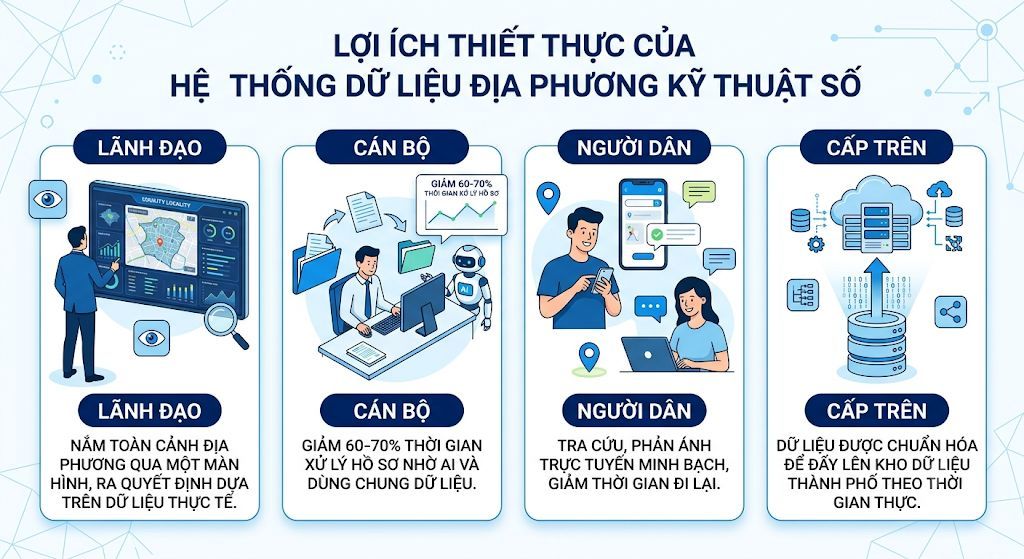
A digital local data system delivers measurable value to leaders, officials, residents and higher authorities.
Grasp the whole locality on one screen and decide on real data rather than manually compiled reports.
Case-processing time drops sharply thanks to AI and shared data — no more duplicate entry across systems.
↓ 60–70% case-processing timeLook things up and file reports online and transparently, track case progress and travel far less.
Data arrives already standardised for real-time push to the city data repository — no more periodic manual consolidation.
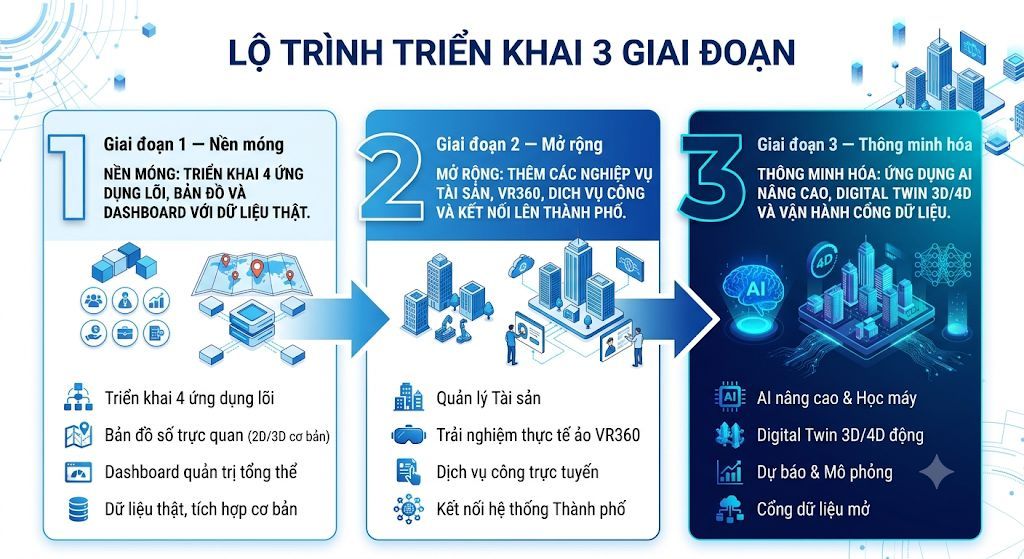
No big-bang rollout. Each phase delivers value you can use immediately while laying the foundation for the next.
Deploy the four core applications, maps and dashboards on real data.
Add asset management, VR360, online public services and the link up to city systems.
Apply advanced AI, 3D/4D Digital Twin and run the open data portal.
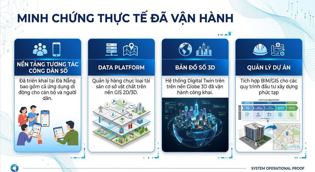
OmniTwin components already run on real data in production, not as demonstration prototypes.
DTGROUP does not sell shrink-wrapped software. We start by understanding the real situation in your own locality.
On-site survey at your ward or commune
Demonstration on your locality’s real data
Advice on the most budget-efficient roadmap